Brett’s Blog (Rainy Stretch Continues)

August 22, 2018 - Leave a Response

There’s rain in the forecast for Thursday.  That’ll be the sixth time it’s rained in Kansas City over the last dozen days.  In that time we’ve netted 2.58 inches of rain.  You can thank an active west to east flow aloft for the suddenly wet weather pattern.

As winds aloft are racing over the Rocky mountains, low pressure areas are developing and heading on the Leeward side of the Rocky mountains.  These Lee side lows then race out across the plains.  We see the next storm in it’s infancy on our midday satellite snapshot.

National Water Vapor.png

Since the circulation around a low pressure system is counter-clockwise our next storm and recent storms pull moisture northward from the Gulf of Mexico.  In some cases there has been a lot of available moisture.  Since the air tends to rise near areas of low pressure, clouds can grow vertically and eventually into showers or thunderstorms.  In a nutshell that’s what’s happening between now and Thursday afternoon.

Surface 7


While the surface winds are from the south tomorrow.  The winds higher up in the thunderstorm may be from a different direction. This is known as wind shear and that change in direction with height can create thunderstorm updrafts. Updrafts can keep water droplets suspended in the clouds creating some severe hail, even in Summer.  Thursday’s thunderstorms will have the potential to create some isolated hail stones larger than quarters and that’s why the Storm Prediction Center has placed KC in a “Marginal Risk” for severe weather.

DMA Severe Risk.png

The better chance for severe weather will closer to the Low pressure area in Nebraska where the temperature profile will be the greatest.  In this region the air aloft could be much colder than the air closer to the ground.  This could create stronger updrafts over Nebraska and South Dakota and will create a small threat for tornadoes in this region.

The tornado threat in Kansas City and surrounding towns is very, very low at this time.  Our biggest threats will be lightning, marginally severe hail and downpours which could lead to some isolated street flooding.  Three out of the four computer models we commonly look at spit out an inch or more of rainfall for this next storm.

Rain Accum Models 48Hr.png

Ah, but do you notice the one model generating a lot less rain.  This must be watched because once again thunderstorms on Thursday will be heavy in some places and just brush by other backyards leaving some with lighter amounts of rain.  And while it appears it will rain Thursday it also appears the weather pattern may turn dry as we head into September.

Brett’s Blog (Soggy Sunday)

August 19, 2018 - Leave a Response

It rained Sunday across much of Kansas and Missouri. And just in the nick of time.  On Thursday, the latest “Drought Monitor” took parts of Missouri and Kansas to the highest category of drought.  Here’s the graphic that shows areas now considered to be in  “Exceptional Drought”.

DMA_Drought_Monitor.png

Because the drought in Missouri continues to get worse, the Governor is getting involved. Governor Mike Parson says he’s going to meet with the Heads of Missouri’s Department of Agriculture, Natural Resources and Conservation.  It’s all an effort to combat the impact of the drought in Missouri.  Both Kansas and Missouri got good news on Sunday when widespread rain fell over much of both states.  Here’s a sampling of rainfall measurements from across the area.

DMA Rainfall Today


Those numbers come from automated weather stations and cooperative weather observers but we also heard from many on Facebook and Twitter.  Here are some other totals passed along to the StormTrack 5 Weather-team on social media.

Viewer Reports via Social Media

Despite more than an inch of rain in many places, we need more rain. The slow moving storm that brought these downpours will bring more rain on Monday.  Not a lot but at this point every little bit will help.

Midwest Forecast Track Rain Accumulation

Let’s hope it rains again on Monday.  We need it.  The next chance of rain is showing up for Friday.  But the next storm doesn’t look well organized which means it could be another case of rain for some, increasing drought for others. Let’s hope not.


Brett’s Blog (Scattered Soakers)

August 15, 2018 - Leave a Response

Tuesday’s showers and thunderstorms offered up some scattered soakers over northeast Kansas and western Missouri.  Just look at the rainfall map from Tuesday and you will see what I mean.

DMA Rainfall Yesterday.png

Nearly two inches of rain in Cameron but Clinton, Missouri picked up just a trace of moisture.  We’ll have scattered showers through Wednesday evening before clear skies  Wednesday night.  More scattered soakers are on the way Thursday afternoon and Thursday night.  We can already see the disturbance that brings our next chance of rain on visible satellite imagery.

National Water Vapor.png

The clear sky we see on the satellite photo will also mean Thursday starts with sunshine. This means the atmosphere will heat up. Thursday’s high in Kansas City warms to near 90-degrees.  Hot surface air coupled with cooler air aloft will lead to rapidly rising air.  Add some stronger winds aloft and we should see updrafts in developing thunderstorms become strong.  This could lead to some isolated or scattered thunderstorms with large hail.  Because of this set-up, the Storm Prediction Center has placed our area in a “Slight Risk” for severe weather on Thursday.

Judging by our in-house computer data, we would likely see most of the action closer to the Iowa border.  But if thunderstorms form closer to Kansas City then we would have to worry about damaging wind gusts and large hail.

Surface 6.png

Lightning would also be likely.  The threat of lightning and wind elevates the chance of Power Outages.  This graphic below uses severe weather parameters and ranks the chance of the power being knocked out by either wind or lightning on a scale of 1 to 4. 1 being low and shaded in yellow, 4 is high and is shaded brown. There aren’t any brown areas on the map below.

Power Outage Index

You might notice an area over northern Missouri is shaded orange. That corresponds with a higher than average chance of power outages.  Why? This area has a better chance to see thunderstorms than other parts of Missouri and these thunderstorms will likely have lightning that could strike a power pole.  Something to keep in mind in you live north of KC.  Otherwise, Thursday’s thunderstorms will be a lot like Tuesday’s storms, Scattered soakers!


Brett’s Blog (Tuesday Rain Update)

August 14, 2018 - Leave a Response

Light rain moved into the Kansas City metro this morning.  So far the amounts have been on the lighter side.  This is pretty typical with this type of upper level low where the eastern side of the storm usually has weak lift and produces a steady period of light rain.  So far this storm is right on track.  Here is a look at a Live Power Doppler Image from around 9 a.m.

KCTV 2018.png

As the low spins toward Kansas City, we will likely experience a dry slot of air that will move overhead during the middle of the day.  Look for the temperature to warm into the upper 70s, especially if the sun comes out which is possible at this point.  But now look at the graphic below and notice the orange areas dotted around the area on Forecast Track.

Surface 1.png

What’s going on here?!  By 3 PM, the center of the upper low will be moving just south of Kansas City.  In this region you’ll find colder air aloft sitting over top warmer air at the surface. This set up generates energy and creates rising air. Rising air equals clouds, add copious moisture and you get thunderstorms.  That’s exactly what we expect to happen from late afternoon into the evening.

Surface 2.png

The severe threat is low with these thunderstorms but don’t be surprised, if one passes over your house, that you experience gusty winds and maybe small hail.  These thunderstorms will also be capable of putting down a lot of water in a short period of time.  Our short range model still insists some areas will end up with more than an inch of rain once these thunderstorms pass through the region.

HRRR Rainfall Forecast.png

Unfortunately, if you don’t get under one of these thunderstorms, then you’re rainfall totals for this storm will likely end up at a half inch or less.  There is another wave of energy forecast to arrive Thursday into Friday.  There is another chance of rain late Sunday.  So, all in all an active period. Now if we could just get the rain to fall in the right places.

Brett’s Blog (Widespread rain headed our way)

August 13, 2018 - Leave a Response

Rain is on the way!  Here is a snapshot of radar & satellite earlier this afternoon.  An upper level low pressure in eastern Colorado will slowly and I mean slowly spin toward Kansas City between Monday night and Wednesday evening.  Look at the amount of moisture the storm is pulling up from the Gulf of Mexico across Texas and Oklahoma. This picture gives us hope that we are in store for a soaking rain.

US Satellite Radar_Blog.png

Remember that winds flow counter-clockwise around a low pressure area.  So as this storm spins toward Kansas City, rain and thunderstorms will first approach from the south and southwest. This will be the case Monday evening. It also means most of the rain will stay just southwest of KC until Tuesday morning.  The heaviest rain will fall near the warm front that forms over southern Kansas and southwest Missouri.

Surface 6.png

Overnight into Tuesday morning, rain and thunderstorms will spread north into Kansas City. These storms will include brief downpours with lightning and thunder.  Early Tuesday the thunderstorms may be more scattered in nature.

Surface 7

But as the low pressure system gets closer to Kansas City, steadier and longer lasting periods of rain and thunderstorms will develop and hang over the KC metro for a number of hours on Tuesday.

Surface 8

As the low pressure area passes Kansas City Tuesday evening it will begin to weaken.  But we won’t be done with the rain. Ample moisture will be available. That moisture will interact with a cold front dropping out of Iowa and we will be in store for more rain on Wednesday.

Surface 9.png

This round of rain could last off and on into Wednesday night before tapering off as slightly drier air filters into the area from the north.  When it’s all said and done many areas could pick up a good soaking rainfall.  Here is a sampling of possible rainfall amounts across the area. Again, these numbers are not set in stone as the rainfall amounts we end up with will likely be higher or lower than what these graphics show.  So why show them? Because it gives you an idea of the rainfall potential from this storm.

Midwest Forecast Track Rain Accumulation

What about severe weather?  The overall threat is low but remember this time of year thunderstorms occasionally collapse, creating strong, if not, damaging winds.  Again the potential is low.  Lightning will be the biggest threat we face with a small chance for some flash flooding.

Severe Risk Index

This slow meandering storm has a lot of moisture to work with so there will be potential for some street and small creek flooding with any thunderstorm that pours over an area. and where there is lightning, power can be knocked out.  But overall the threat is low.

Bottom-line, the severe threat is limited. The rainfall should be widespread. In other words, rain is on the way!


Brett’s Blog (Much Needed Rain)

August 12, 2018 - Leave a Response

It seems we’ve been talking about it for days.  A large, slow-moving, meandering storm took shape along the Red River in Texas and Oklahoma Sunday night. This “L” on the map below is the storm we are tracking.

US Satellite Radar_Blog.png


This area of low pressure will slowly move its way north on Monday.  By Tuesday morning, the storm will hook up with a surface low pressure area. This should lead to the first widespread, long-lasting, soaking of rain in months.  The rain, at first, will likely be off and on and spotty Tuesday morning but pick up in intensity and coverage Tuesday afternoon.  Here is what the surface weather map should look like Tuesday morning.

Surface 6.png

Tuesday afternoon, the warm front associated with the low pressure area will lift into the Kansas City area.  Our chance of rain will increase to 90-percent and we should have embedded thunderstorms with some downpours possible when the warm front moves through the area. This is when I expect to see a steady rain for a few hours Tuesday late afternoon and evening.

Surface 6-2.png

There may be a few rain showers Wednesday morning when the “cold front” in Iowa (on the map above) drops into Missouri and Kansas. Behind this cold front, another upper level disturbance will likely produce several hours of light rain or drizzle through Wednesday evening.

Surface 6-3.png

All in all it should be a very beneficial rain for most of us.  Below I will show you a forecast rainfall map. Remember these numbers are not set in stone and exact amounts will likely change or shift once it starts raining.  But this gives us some guidance or an idea of the range in rainfall measurements we will experience with this upcoming rain event.

Midwest Forecast Track Rain Accumulation

That would do a lot to ease drought conditions in the area. And remember this is forecast rain through Wednesday evening.  Another storm system moves into the northern plains Friday that could produce another round of steady, light to moderate rain.  If this week comes together as computer models suggest then we will talk about this mid-August rain for days!


Brett’s Blog (Showers Tonight, Meteor Showers)

August 11, 2018 - Leave a Response

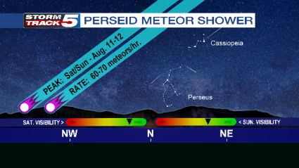
Showers are in the forecast tonight!  Meteor showers! The annual Perseid meteor showers peak Saturday and Sunday night.  For best viewing look toward the north, northeast sky after midnight.  Most of the meteors should originate between the constellations of Cassiopeia and Perseus

Meteor Shower Template

This year 60 to 70 meteors an hour will be visible, especially late tonight and Sunday night after the crescent moon has set.  I am a little concerned about a hazy screen of smoke particulates high in the atmosphere blurring the visibility. Otherwise skies will be clear.  While Saturday night will be a great night for viewing the Perseids, many astronomy experts say Sunday night may offer a better show.  Either way, showers are in the forecast but you won’t need an umbrella, just a patience and great view of the sky.

Brett’s Blog (Colorful Sunsets)

August 10, 2018 - Leave a Response

Red Skies at night!  We’ve had a lot of them lately! For instance, Friday evening over KCI.

CityCam Video 2

Look at all the pinks, reds and oranges in this sunset.  What’s causing such colorful sunsets?  The simple answer, the smoke from the wildfires out west.  How can that be? Can the smoke from hundreds of miles of away be impacting us here in KC?  Yes!  But the smoke particles are so high up in the atmosphere and so diluted when they get to KC that we can’t smell it and it’s not having an impact on our air quality.  But it is providing a lot of colorful sunsets.  Check out this photo, also from Friday evening as the sun sets over the Legends and Village West in Wyandotte County.

CityCam Video 3

Typically we see a lot more color at sunrise or sunset because the sun’s rays are passing through more atmosphere than at any other time of the day.  For instance when the sun is 4-degrees above the horizon, sunlight has to pass through 12 times more atmosphere than when the sun is right overhead.  Most of the shorter wavelengths are scattered away by air molecules!  So, air and water molecules, dust and smoke in the atmosphere filter out certain wavelengths leaving our eyes to only see certain colors.

Recently the atmosphere has been so loaded with smoke particles from western wildfires that only the longest red wavelengths have been able to penetrate through the atmosphere.  And when enough orange and yellow wavelengths are scattered out the sun can appear red!

So red skies at night!  We are going to have a lot more of them this Summer, as long as the wildfires keep burning out west!

Brett’s Blog (More Ding Than Dent)

August 7, 2018 - Leave a Response

The much advertised rain arrived last evening and continued overnight into the first half of Tuesday.  Here’s a look at official rainfall amounts from across the region.

DMA Rainfall Today.png

I wouldn’t say this rain put a dent in the drought.  It was more like a door-ding.  And once again, as has been custom this Summer, it was another feast or famine rain. Below are some radar estimates of rainfall. First, around metro KC and the second graphic expands to show regional rainfall Doppler radar estimates.

KCTV 2018

KCTV 2018_2

One to four inch rainfall amounts appear common.  But sometimes hail can elevate radar estimates. There was some hail in a few of these cells across the northern Missouri so the four inch total near St. Joe may be due to hail contamination but still a healthy drink of water.

So, how far are we behind now in rain?  Here is the latest rainfall report from Kansas City International.

Kansas City Rain

Our next, best chance of rain may not come until the middle part of next week.  Hopefully that will produce the rainfall amounts being advertised by the computer data.  But this far out, a lot can change.  As always, stay tuned!


Brett’s Blog (Monday Night Thunderstorms?)

August 5, 2018 - Leave a Response

There’s a chance of thunderstorms Monday night!  But will it happen?  Computer data has over-promised on rain many times this Summer, so will this finally be the time it rains as advertised?  I’m giving you a heads up in case these thunderstorms develop.  A Marginal Risk of severe weather exists in and around Kansas City for Monday night and Tuesday morning.

DMA Severe Risk plus box.png

Why? Because these thunderstorms could develop very late at night and develop near Kansas City.  These are the thunderstorms that can produce thousands of lightning strikes, dump a quick inch of rain, drop some hail and blow a fierce wind into your backyard all while we are sleeping.  So I just want you to be aware.  Here’s a snapshot of what radar could look like around 3 AM.

New Surface Move.png

These thunderstorms may get a boost from the night-time low level jet stream.  These low level winds develop about five thousand feet above the surface and thunderstorms can carry these winds to the surface.  That might explain why our in-house computer model thinks strong winds in excess of 50 mph will come with the thunderstorms around 3:00 AM.

Severe Wind Gusts.png

Look carefully at the image above and you can see an area of purple that matches a wind gust of more than 50 miles per hour.  Now look just to the right of the purple area. Do you see how the whole area of colors looks curved on its edge?  This would be an outflow boundary that would produce gusty winds before the rain and thunder arrives.  You’ve probably heard wind chimes or leaves rustle before the rains?  Probably some kind of outflow boundary announcing the rains arrival.  Oh, and there is one more threat that comes with these thunderstorms.  Quarter-sized hail.  There might be just enough wind shear to produce some hail. At least that’s what the guidance suggests.

Forecast Hail Threat

Bottom-line, there could be thunderstorms Monday night and early Tuesday morning.  We could use the rain.  Just don’t be caught off guard if the wind starts howling and hail starts falling.  Of course, we will do our best to keep you up to date on what’s blowing through KC.